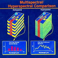
 本實驗室於遙感探測領域的研究包含了高光譜影像資料之分析與多光譜影像資料之應用。隨著現代光學技術的發展,高光譜感測器能提供較高的光譜解析度及較窄的波譜範圍,藉由這些豐富的資訊能夠加強影像特徵辨識的能力及分類的精度。(https://www.fas.org/irp/imint/docs/rst/Sect13/Sect13_9.html)
Our laboratory researches in the field of remote sensing focuses on the analysis and applications of hyperspectral image data. Recently the development of remote sensing technology have rendered a hyperspectral sensor which can provide wide spectral range and narrow spectral band for the acquired spectral images. Such characteristic strengthens the ability of feature recognition and object classification from the images.(https://www.fas.org/irp/imint/docs/rst/Sect13/Sect13_9.html)
與高光譜影像資料之分析相關的研究包含藉由分析影像資料特性並利用統計理論探討類別分群的方法,接著移除波段相關性並計算資料分離度以解決無法適用傳統多光譜影像分類技術造成分類效率慢及無法提升分類精度的問題。另外,結合影像平滑處理與特徵萃取,萃取出對分類有幫助的資訊也能提升分類的效率與精度。
A classification strategy can be investigated by analyzing the spectral features of the sensed objects with statistical tools. Usually the traditional classification methods suffer from the inefficiency of processing and poor classification accuracy. The problem can be solved by easing the correlation of data features between each hyperspectral band. In addition, by applied some pre-processes such as image smoothing and feature extraction can also improve the efficiency and classification accuracy.
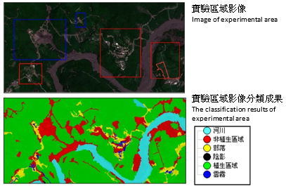
與多光譜影像資料之應用相關的研究包含利用前後期多光譜衛星影像特徵偵測崩塌地,藉由物件導向模式及建立資料庫的分類方法找出適合分類的特徵條件,以提升判識的精度,解決傳統監督式或非監督式分類法於光譜性質相似地物分類時產生混淆的問題。
Our previous works related to remote sensing topics is using multi-temporal multispectral satellite images to detect landslides. Based on object-oriented classification method and a pre-established database, we can obtain effective feature information for the purpose of classification. Thus the accuracy of identification is superior to the traditional supervised or unsupervised classification method which may misclassify when the terrain is composed of many complicated or similar primitives.