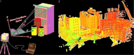
 光達是一種主動式遙測技術,如圖所示,利用雷射測距的方式,以固定的頻率針對場景進行掃描,加上定位定向系統(Positioning and orientation system),可獲取高精度的點雲資料(三維點群座標),以及感測物的回訊訊息,包含反射雷射光的強度(Intensity)以及雷射脈衝經地物反射之數目(Number of return)。目前常見的應用包含地形監測、地物特徵萃取、地物分類….等,使用光達產製空間資訊產品也更為容易,例如:房屋模型、數值高程模型(DEM)、數值表面模型(DSM),更可結合直接地理定位的方式,獲取建立在當地座標系統下的點雲資料,方便用於地形圖、地籍圖的繪製,變遷分析……等,相較於傳統測量,利用光達技術獲取空間資訊節省了許多資料處理的時間。
本研究室對於光達資料的分析相當廣泛,以資料面來看,包含空載光達的航帶平差、地面光達的多測站平差、地面光達幾何校正系統……等,在空間資訊產品方面,包含利用空載光達進行特徵萃取、地物分類、評估樹冠高度模型及葉面積指數、產製數值高程模型之品質評估等。
LiDAR is an active remote sensing technique. As the figure shows, LiDAR scans the scene with a certain frequency by laser ranging. Equipped with positioning and orientation system, we can acquire high accuracy point cloud data in a local coordinate system, and the information of return signal including the intensity and the number of returns. Some conventional applications include terrain monitoring, feature extraction, classification. It is much easier to produce the spatial information product. For example, building models, digital elevation model (DEM), digital surface model (DSM). It can also combine the technique of direct geo-referencing to acquire point cloud data constructed in the local coordinate system. It is convenient for the mapping of topography and cadastral, analysis of changes. Compared with traditional methods, it saves much more time for data processing by using LiDAR technique.
Our research on LiDAR is in many aspects. Based on the data processing, a strip adjustment, adjustment of multiple stations and the calibration system of terrestrial LiDAR are included in our studies. In the aspect of spatial information producing, the studies included feature extraction, classification, estimation of forest canopy height model and LAI, quality assessment of DEM generation and so on.
空載光達全波形資料之應用
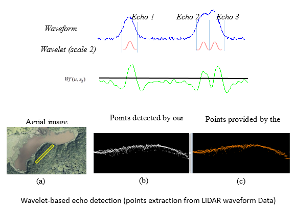
在空載光達系統可儲存完整的全波形資料後,我們即可自行發展響應偵測演算法來重新偵測波形中的響應。本實驗室即提出來一個小波響應偵測法來偵測未被光達系統所”看見”的重跌回訊,小波轉換同時亦有抑制雜訊的功能,有助於避免偵測出雜訊點位。重新獲取這些點位的一個好處是,有更多的地面點位可以被找出來(尤其在森林上),因此,地表可以被表示的更為連續,如下圖。
Researches on airborne waveform LiDAR
The availability of waveform data enables us to develop algorithms to detect the echoes that are implicitly contained in waveform signals. We proposed a wavelet-based detector that can resolve overlapping echoes and suppress background noises in waveforms so that more points can be extracted compared with the points provided by the system. A straightforward advantage of having more points is that the terrain can be represented more continuously (see the figure below).
除此之外,波形亦紀錄額外的地面物理特徵(與傳統離散光達系統做比較),因此可利用波形的特徵來改善傳統光達特徵在分類上的精度。
Besides, the waveforms can provide additional features (compared with the conventional discrete LiDAR system) that represent the physical characteristics of illuminated surfaces. The classification using waveform data is potentially expected to be improved.
本實驗室亦利用波形資料同計算業面積指數,葉面積指數是森林參數中一個相當重要的指標,其可以被用在許多的森林應用上。而我們透過光達資料計算LAI的方式乃利用雷射穿透率來與葉面積指數做連結,兩者乃具有成反比之比例關係,因此可作為推估之依據。
Our lab also took the advantages of waveform data to derive Leaf area index (LAI). LAI is one of the key forest parameters that can be used to apply to many forest applications. Our objective is to use the LiDAR characteristic - penetration ability – to estimate the LAI. The leaf penetration index (LPI) can be computed from the LiDAR data and many researches have shown that LPI is inverse proportional to LAI. Thus a transformation between LAI and LPI can be estimated.